Weather Underground – by Bob Henson
While southern California tries to dry out from Friday’s watery onslaught, yet another atmospheric river will be pointed at central and northern California from late Sunday through Monday, exacerbating the woes of what’s already been a record-wet winter to date across the northern Sierra. Precipitation totals of 10” or more are possible early this week across parts of the Feather River watershed feeding into Lake Oroville. This is bound to push lake levels toward a new spike even as water continues pouring from the lake’s damaged main spillway. Fortunately, the lake level was down almost 50 feet on Saturday from its overflow state last Sunday, February 12, when the emergency spillway showed signs of failure that prompted the evacuation of more than 180,000 people. By Saturday, the amount of water in the reservoir had dropped to 81% of capacity. This greatly reduces the odds that the impending storm could bring the lake back near capacity.
While officials will be monitoring the Oroville situation and continuing their spillway repair work, many other dams and levees across the region will come under increasing stress as this week’s rains fall atop already-saturated ground. “Given record wetness to date, Monday #AtmosphericRiver will be stress test for CA water infrastructure,” noted Daniel Swain (California Weather Blog).
![]()
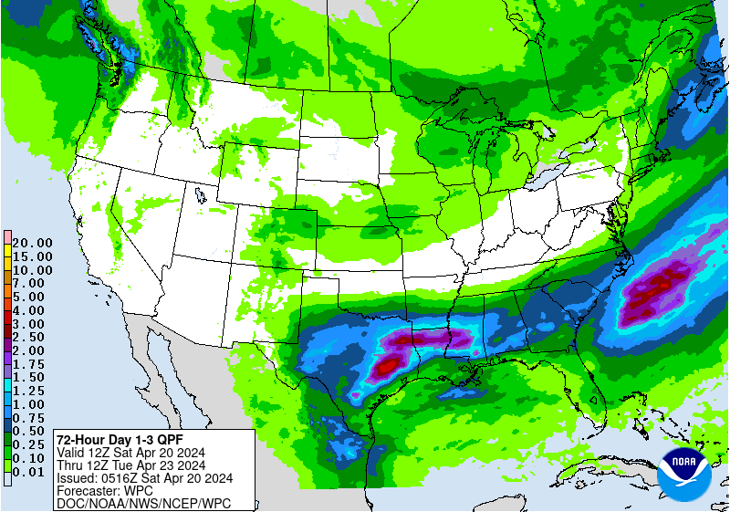
Figure 1. Precipitation forecast for the 3-day period from 4:00 am PST Sunday, February 19 to Wednesday, February 22, 2017. Amounts in California amay peak at more than 10” at higher elevations of the Bay Area and in the northern Sierra. Image credit: NOAA/NWS Weather Prediction Center.
Now it’s the Bay Area’s turn
The impending storm is likely to pack a big punch for city dwellers from San Francisco to Sacramento. Models have been varying on the location and movement of the atmospheric river, or AR, which is expected to push across the Monterey area late Sunday and gradually work its way northward into Monday. The AR’s orientation over time is the critical variable in how much rain falls across the heavily populated corridor from San Francisco to Sacramento. Although Friday’s storm caused widespread local havoc in parts of Southern California, it brought a bit less rain than feared to the immediate Los Angeles area (2.01” in downtown Los Angeles), as the main moisture channel ended up focused just a bit further west. Santa Barbara’s airport experienced its wettest February day in 77 years of recordkeeping with 4.16” on Friday, beating out 3.97” from Feb. 8, 1985.
The AR heading into the Bay Area late Sunday is expected to be carrying at least 1.25” to 1.5” of precipitable water (the amount of moisture in the column of air above a particular spot). The higher end of this range is seen on average once every 5 to 10 years in the area, noted the Sacramento office of the National Weather Service. Overall, the southwest-northeast-oriented AR will lift northward with a warm front late Sunday into early Monday, then sag southward with the subsequent cold front later on Monday. Between the rich moisture feed and strong atmospheric dynamics, the potential exists for totals of 3” or more of rain at lower elevations–even in the Bay Area cities–should the AR stall for very long over a particular spot. The GFS model has been particularly bullish on the potential for very heavy amounts. In those places where the AR shifts north or south fairly quickly, totals may end up closer to 2” or less. Official forecasts are calling for 1.5” – 2.5” in the Sacramento area and 2” – 5” in and near San Francisco. As usual, much higher amounts can be expected at higher elevations, and flooding and mudslides will again be a distinct threat. High winds will topple vulnerable trees in increasingly wet soils.
Longtime Bay Area forecaster Jan Null (Golden Gate Weather Services, @ggweather) expects that Oakland could see 3”, with 6” – 8” in the Coast Range above 2000 feet. “I think this will be a memorable President’s Day Storm,” Null told me. “There will be major problems in the swath from the Bay Area to Lake Tahoe. Lots of slides, trees down, and localized flooding. I am actually recommending people stay home on Monday.”
What are the records to beat?
California precipitation is notoriously variable, and we’re fortunate to have records extending well back into the 19th century to remind us of this. Even though climate change is boosting the intensity of extreme rainfall in many parts of the world, most of the heaviest 1-, 2-, and 3-day rainfall events in central California occurred before the year 1900, as shown below. Records go all the way back to 1877 in Sacramento and 1849 in downtown San Francisco.
Maximum 1-day rainfall
Sacramento: 5.28” (Apr. 20, 1880)
San Francisco: 5.44” (Nov. 5, 1994)
Maximum 2-day rainfall
Sacramento: 8.37” (Apr. 20-21, 1880)
San Francisco downtown: 7.90” (Dec. 19-20, 1866)
Maximum 3-day rainfall
Sacramento: 8.81” (Apr. 19-21, 1880)
San Francisco downtown: 8.85” (Dec. 18-20, 1866)
Only a dozen two-day rainfalls have topped 5” in San Francisco, and just three of those have occurred in the last century: 6.78” (Jan. 5, 1982), 6.76” (Nov, 5-6, 1994), and 5.68” (Nov. 4-5, 1994). Only three calendar days have seen more than 4”.
![]()
Figure 2. A before-and-after shot of Cachuma Reservoir, located north of Santa Barbara. The amount of water in Cachuma Lake has more than tripled since the start of February. Located on the leeward side of the Santa Ynez Mountains, Cachuma Reservoir often misses out on big precipitation events, and drought relief had been limited in the area till the last couple of weeks. As recently as late January, the reservoir held only 9% of its capacity and 13% of its historical average for that date. As of Saturday, the lake held 32% of its capacity. Image credit: Santa Barbara County, @countyofsb
![]()
Figure 3. Water expert Peter Gleick (Pacific Institute) tweeted this astonishing image on Saturday: “In an average 12-mo California #water year, northern CA gets 50 inches of rain. The first half of the 2017 water year has produced 70 inches.” On average, northern California has received about 65% of its water-year total by this date–about half of what’s actually fallen this water year. Image credit: California Department of Water Resources, annotated by Peter Gleick, @PeterGleick.
Get set for one of the warmest winter weeks on record in the heart of the Midwest
St. Cloud, Minnesota, hit 59°F on Saturday–tying the warmest reading observed in St. Cloud during any February in 123 years of recordkeeping (that record occurred just last year, on Feb. 27, 2016). International Falls also tied its February record on Saturday with 58°F, previously set on Feb. 22, 2000. A number of Midwestern cities set or tied their second-warmest February reading on Saturday, including:
Detroit, MI: 69°F (monthly record 70°F on Feb. 11, 1999)
Flint, MI: 65°F (monthly record 68°F on Feb. 11, 1999)
Minneapolis, MN: 63°F (monthly record 64°F on Feb. 26, 1896)
Milwaukee, WI: 67°F (monthly record 68°F on Feb. 11, 1999)
Sault Ste. Marie, MI: 49°F (monthly record 50°F on Feb. 16, 1921)
Saturday’s warmth is a harbinger of a very mild week to come for the heart of the Midwest, especially across snow-starved northern Illinois. As reported by Chicago weathercaster Tom Skilling, the city’s longest winter period without a one-inch snowfall in records dating back to 1884 was a 64-day streak that occurred twice: Dec. 3, 1905, to Feb. 4, 1906, and Dec. 23, 1953, to Feb. 24, 1953. Chicago’s last inch of snow fell on Dec. 17. With no snow in the forecast, the city’s snow-drought record will fall on Monday when the current streak hits 65 days. Other cities experiencing an unusual lack of snow this winter thus far, as noted by Illinois state climatologist Dr. Jim Angel:
• Champaign: 4.6” (record is 6.7 inches in 1953-54)
• Springfield: 5.7” (record is 5.8 inches in 1953-54)
• Peoria: 9.5” (record is 7.8 inches in 1965-66, 1994-95)
The extreme lack of snow is helping an already-mild pattern maximize its potential for warmth at ground level. Rockford, IL, cracked 60°F on both Friday and Saturday, and the forecast is for Sunday through Wednesday to do the same, making for a six-day streak. No winter (Dec/Feb/Jan) has ever brought Rockford more than three 60-degree days in a row. Chicago may also manage a 6-day streak of 60-degree days, which would break its longest winter streak of 5 days set on Dec. 2-6, 1998. Records extend back to 1872 in Chicago and 1893 in Rockford. Even Detroit could rack up a solid week of temperatures breaking the 50°F mark, which would be just one day short of its record for any February.
We’ll be back on Monday with more on the California rains, including the dousing that caused several deaths and massive disruption across the Los Angeles-Santa Barbara area.
Bob Henson
Moisture laden subtropical air going for #CA, loop is 4 am Sat-1 am Sun.
Light rain now reaching #BayArea, VERY WET+WINDY late this PM-Tue. pic.twitter.com/VDYO0RdRSS— NWS Bay Area (@NWSBayArea) February 19, 2017
https://www.wunderground.com/blog/JeffMasters/no-rest-another-round-of-intense-rains-heading-for-central-and-northe
I’m having a problem sending an email to the Trenches. Unknown why.
The smart folks will already have their swimmin flippers.
If California or the west had half a brain, they would have had dams in place to harvest this rain and end the drought for a hundred years.
Was living in Tahoe Vista, on the North Shore of Lake Tahoe throughout the ’90s
3 to 4 feet over night a few times, ’94?, oh yeah!
yup, was still skiing, when feasible
heck, if anyone lives around N Nevada, let me know, would be great to rally with a fellow trencher on the slopes! Even some mountain trekkin’ would be swell, BS’n etc.
Is God mad at the libs in California?