Severe thunderstorms with tornadoes, damaging winds, large hail and flooding rain will return to the Plains Friday, lasting into early next week, bringing an end to a relative lull in severe weather.
The jet-stream pattern will essentially flip late this week, taking a much farther southward plunge over the Rockies, then punching its energy eastward into the Plains states this weekend.

When this happens, wind shear – the change in wind speed and/or direction with height – is much higher, and warm, humid air streams into the Plains from the Gulf of Mexico.
This combination is expected to support severe thunderstorms as soon as Friday evening in the Plains, continuing into this weekend. A second jet-stream plunge is then expected to swing into the Plains early next week, triggering another round of severe weather.
Given May’s reputation as the peak month for tornadoes in the U.S. and saturated soil from recent heavy rain in the Plains, this active pattern has our attention.
(MORE: It’s Been Almost 6 Years Since the Last EF5 Tornado)
Severe Weather Outlook
Typical for severe weather outlooks several days away, some uncertainty remains in this forecast, but the generalities of some of the days ahead are becoming clearer.
Supercells and long lines of severe thunderstorms known as squall lines are both possible at times, with tornadoes, damaging winds, large hail and heavy rain.
It’s too soon to determine details such as the magnitude and location of the tornado threat each day.
Here is our current forecast for now. Check back with us at weather.com for important forecast changes in the days ahead as the details become clearer.
(MAPS: 7-Day U.S. National Forecast)
Friday
Scattered supercell thunderstorms are possible by afternoon or early evening in the High Plains from Nebraska to western Oklahoma and the rolling plains of West Texas.
This activity may evolve into one or more overnight thunderstorm clusters from west-central Texas to Nebraska, South Dakota, southwestern Minnesota and Iowa.
Saturday
Numerous severe thunderstorms are expected from parts of Nebraska and Iowa to Central Texas, continuing into the night.

(The area shaded in red indicates the highest confidence of at least some severe thunderstorms Saturday. Other areas of rain and thunderstorms are shown in various shades of green.)
Sunday
This is a more uncertain forecast, but at least some severe thunderstorms are possible from parts of the lower Ohio Valley to the lower and mid-Mississippi Valley and mid-South.

(The area shaded in red indicates the highest confidence of at least some severe thunderstorms Sunday. Other areas of rain and thunderstorms are shown in various shades of green.)
Monday-Tuesday
Scattered severe storms are possible Monday afternoon in the Plains from Kansas, perhaps southern Nebraska, to western Oklahoma and the Texas Panhandle.
Next Tuesday, that severe threat may become more expansive in the Plains, somewhat analogous to Saturday, from the Corn Belt of Nebraska and Iowa to North Texas.
In Tuesday morning’s extended forecast outlook, NOAA’s Storm Prediction Center (SPC) highlighted areas of severe threat on each of their days 4 through 8 – Friday through next Tuesday – for the first time since it began issuing daily extended severe weather outlooks in 2008, according to Patrick Marsh, NOAA/SPC warning coordination meteorologist.
Flash Flood Threat
Repeated rounds of heavy rain over the past week or so triggered significant flooding in parts of Kansas, Oklahoma, Texas, Louisiana and Mississippi, including cities such as Houston; Baton Rouge, Louisiana; and Jackson, Mississippi, among others.
It was the wettest first 12 days of May on record in Dodge City, Kansas, the wettest such period since 1904 in Austin (Camp Mabry), Texas, and since 1978 in both Jackson, Mississippi, and New Orleans, according to the Southeast Regional Climate Center.
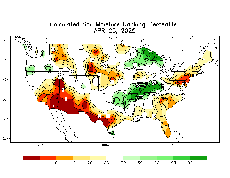
Soil moisture remains in the 99th percentile over a vast swath of the nation’s midsection, and some rivers are still above flood stage from the northern Plains to the Gulf Coast.
These upcoming rounds of severe storms may produce at least locally heavy rain at times over parts of the saturated Plains or Mississippi Valley, potentially triggering flash flooding in at least some spots.
(MORE: Another 1993 Great Flood? Probably Not, But There Are Concerning Signs)

(This should be interpreted as a broad outlook of where the heaviest rain may fall. Higher amounts may occur where bands or clusters of thunderstorms stall for over a period of a few hours.)
It’s not yet clear whether next week’s thunderstorms will progress eastward in similar fashion to this weekend’s storms, or if the frontal boundary will stall in the Plains.
If the front stalls, this could lead to additional rounds of soaking thunderstorms, which could raise the flood threat.
And they say trucking is a low skill job, tell you what you commie asshats, get your lazy punk ass out here and roll one of these 80,000 lb trucks through severe weather, while staying alive… cheap ass MFKRS! KISS MY ASS..
Do you fly your private jets through this shit?..
BAM!
We’ve been lied to about global warming which they now call climate change. Yes, the climate is changing and humans only contribute a minuscule amount. The sun is the driving force according to models and is in a slow active phase and will be for some time. According to the real science, weather & earth activity will be considerably erratic and intense.
Yep, solar minimum (or even grand solar minimum)…for ANYONE to say humans cause climate change is not only ridiculous, but is an affront to the Controller of all things, GOD! (Or, if you are an atheist, the Sun).
Been going on since the birth of earth. Hot, Cold…Hot, Cold…only thing different is the size of Al Gores waste size, and size of the corrupt, fat pigs bank accounts.
IMO this is part of the plan.
agree…..
“Never let a good crisis go to waste”, so says Rham Emanuel. It is certain they are en-devouring to capitalize on the suns activity.
I don’t discount the effect that all the chem-trailing has done. I’d be wise to listen to and understand the science and the scientists that are NOT skewing data nor participating in the deception.
ANYTHING that proceeds from the mouths of so called govt. I invert 180 degrees. They say the earth is warming & the cause is human, so I then know the earth is cooling and the sun is the cause. Real simple to my brain.
today we are going to have weather , and tomorrow more of it
being a weather man is a joke ..its the only job i know where you can be wrong 95% of the time and still get paid
the only people who are a bigger joke are politicians